
Iconic Big Sur, California Road Trip Stops
Driving down the scenic Pacific Coast Highway is, without a doubt, one of the most iconic routes one can take
The motto “the journey is the destination” certainly applies to Big Sur. Highway 1 winds along a 71-mile (114 km) stretch of the coastline of Big Sur. Along the way, breathtaking views, redwood forests, some of the best hiking trails (for any level), charming restaurants and hotels, as well as enchanting beaches can be found.
Big Sur is the California that men dreamed of years ago, this is the Pacific that Balboa looked at from the Peak of Darien, this is the face of the earth as the Creator intended it to look. ~ Henry Miller
Heads up: this post contains affiliate links. If you click on an affiliate link and make a purchase, you won’t pay a penny more, but we’ll get a small commission, which helps keep the lights on. Thanks!
Where is Big Sur and why should you visit?
Big Sur is located on the Central Coast of California between Carmel and San Simeon. Here, the Santa Lucia Mountains acutely rise from the Pacific Ocean which creates an extraordinary landscape.
Bis Sur is known as one of the most scenic coastlines in the world, and the perfect road trip destination. Highway 1 (California State Route 1) connects San Francisco in the North with Orange County in the South. Condé Nast Traveler named State Route 1 through Big Sur one of the top ten world-famous streets, comparable to Broadway in New York City and the Champs-Élysées in Paris.
The drive along the Big Sur coastline can easily be done in one day. However, if you would like to go on some hikes, we would advise you to spend a night in one of the great hotels / B&Bs / campsites. Book your room well in advance as there is limited availability in Big Sur.
These are the few accommodations we would recommend in Big Sur:
- Big Sur River Inn (located in “Big Sur Village” next to namesake river and also has a Restaurant)
- Big Sur Lodge (close to Pfeiffer Falls Trails and Big Sur River Gorge)
- Fernwood Resort (motel and cabins – budget option)
- Lucia Lodge (great location and price/value)
- Alila Ventana Big Sur (adults only, 5* resort & spa)
- Post Ranch Inn (exclusive 5* resort)
We managed to drive from Monterey to McMay Falls and back up to Monterey in approximately 10 hours with countless stops and a few short hikes. We had to drive back up due to a road closure caused by a landslide. This drive is by no means dangerous though. Just always check ahead of time if there are any road closures as there is no detour available.
Big Sur has several state parks and reserves, as well as several areas that are federal land, and are therefore protected and not very developed apart from small residential communities. The Big Sur region stretches much further inland than most visitors cruising along the coastline would imagine. The Santa Lucia Mountains extend between 3 to 12 miles (5 to 19 km) inland, and some consider the Big Sur eastern border to be at the foothills of the Santa Lucia Mountains.


How is the weather in Big Sur?
The weather in the Central Coast of California is relatively consistent with highs between 15°C (60°F) degrees in January and 25°C (77°F) degrees in summer, and lows between 6°C (43°F) degrees in January and 10°C (50°F) degrees in summer.
January to March sees around 8 days of rain, April and May between 2 and 5 days of rain. It usually does not rain between June and August, 1-2 days of rain are expected in September and October, and 5-8 days of rain in November and December.
When is the best time for a Big Sur, California road trip?
During summer weekends and on all major holidays, Big Sur sees an overwhelming amount of visitors. Sometimes there are severe traffic jams and all parking lots on trailheads, beaches, and scenic points are full. Hence, we would recommend visiting in either spring (May) or fall (September, October). Also, try to avoid weekends. An early morning start is always advised to get a head start and find the attractions empty and calm. We’ve visited in November the last time and the weather was great – sweater weather but sunshine from late morning to evening, empty beaches and almost no traffic.
Is there a town in Big Sur?
The region is protected under the Big Sur Local Coastal Plan, which preserves it. While there is a town referred to as Big Sur Village by locals in the Big Sur River Valley around 26 miles (42 km) south of Carmel, there is no official city known as Big Sur.
Where to start a Big Sur road trip?
If possible, start in the north and drive south so you drive on the roadside next to the ocean for the best view. You can drive down from San Francisco and stop along the way or start closer to the Big Sur region.
Monterey is the perfect point of departure for a Big Sur road trip in our opinion. Not only is Monterey worth a visit in itself, but it also offers many options for accommodations and the 17-Mile Drive can’t be missed when visiting the area. The city has always attracted artists and there are several music and art festivals every year. One of the most famous citizens was John Steinbeck, author of “Cannery Row”. His old house in Salinas is open for visitors.
Other attractions are the Monterey Bay Aquarium, Lover’s Point Grove, Cannery Row, Monterey coastal trail, the sea lion lookout, Fisherman’s Wharf, Monarch Grove Sanctuary, and whale watching tours. There are great scenic flights over Big Sur offered from the Monterey airport for a birds-eye perspective.
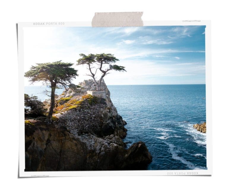
The 17-Mile Drive is a scenic road on the Monterey Peninsula through Pebble Beach and Pacific Grove. The road follows the coastline, passes the famous golf course, lavish mansion, and attractions including the Lone Cypress, Bird Rock, and the Del Monte Forest. The primary entrance (~$ 10 fee) to the 17-Mile Drive (27 km) is at the California State Route 1, which makes it the perfect starting point for the Big Sur road trip.
The exit is north of Carmel-by-the-sea which is a perfect pitstop with its charming, bohemian city center with lots of artisanal coffee shops, bakeries (our favorite bakery is “Carmel Bakery”), and shops. Carmel Beach has powdery sand and allows dogs, has a great hiking trail, and surfing lessons are readily available.
Before you head down Highway 1, make sure your gas tank is full, everyone went to the bathroom, you have offline maps available, and some snacks and water. There are very few gas stations and restaurants along the next stretch of the road. Also, cell service can be very spotty so don’t rely on online maps/navigation. However, it’s almost impossible to get lost – just keep the ocean to your right side.
Best hotels in Monterey and Carmel-by-the-sea
there are quite a few options to choose from in these two cities and we would like to share our favourites with you.
Boutique Hotels/Inns:
Luxury:
Spindrift Inn (ocean front)
Monterey Plaza Hotel & Spa (ocean front)
Tickle Pink Inn


THE TOP 10 MUST-SEE STOPS ON YOUR BIG SUR ROAD TRIP
1. - 3. Point Lobos State Natural Reserve
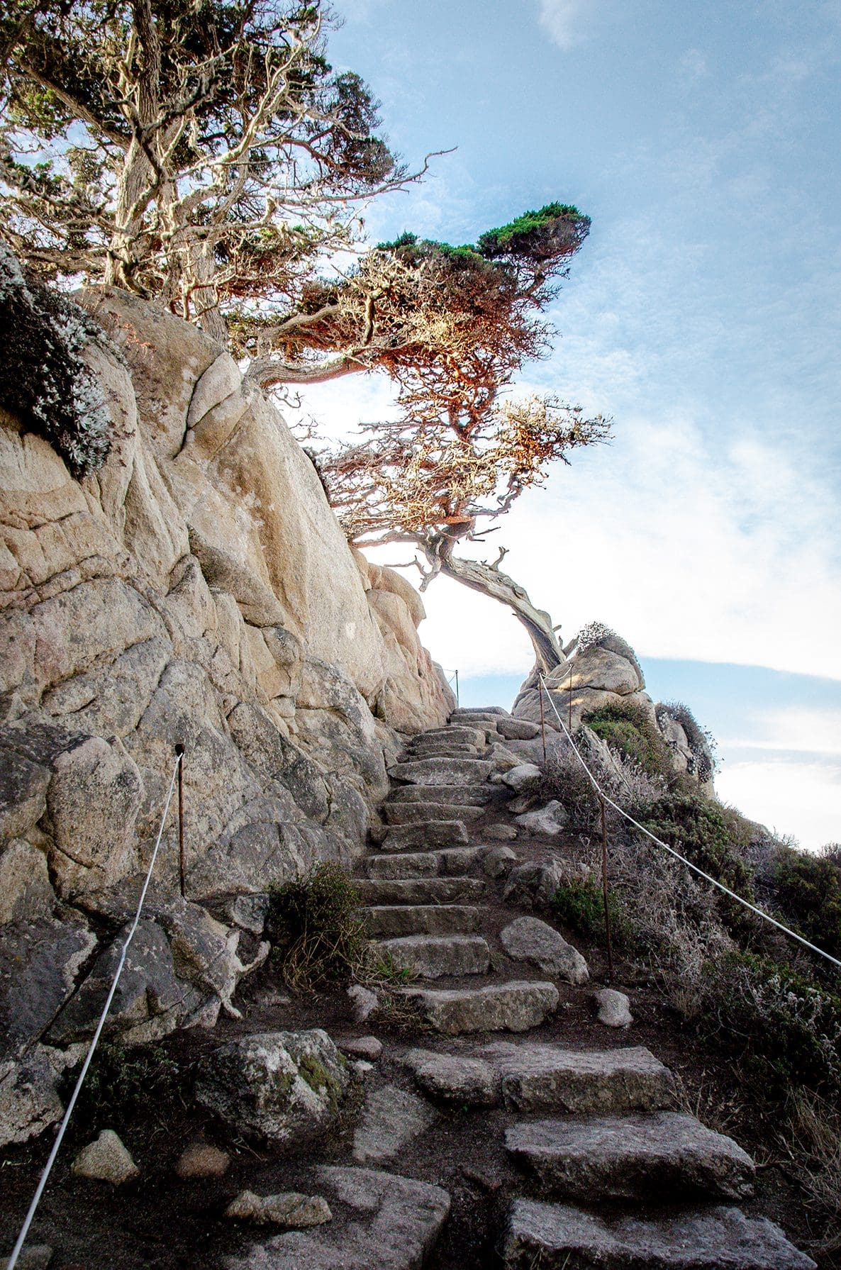
Coming from Carmel, the first stop is only a few miles down the road – Point Lobos State Natural Reserve. If you prefer a scenic stroll to a strenuous hike, Point Lobos offers the perfect hikes for you.
After taking the Point Lobos State Park exit, follow the road to the first parking lot. From there the Cypress Grove trail is in our opinion one of the top stops with its scenic and picturesque views. The 0.8 miles (1,3 km) loop trail with a very little incline is a photographer’s dream with endless photo spots.
The trail itself is mostly lined by old, tall cypress trees, Spanish moss dangling from the branches giving it a very dreamy ambiance. With the ocean on the left and the cypress forest on the right, the trail winds along, and behind every corner is a new, breathtaking view. The ocean surprises you with its incredibly turquoise water.
The trails are always well maintained, safe, and in parts with safety rails – just in case. While 0.8 miles won’t take longer than 25 minutes to hike (walk) plan some extra time for all the stops you’ll take to admire the landscape and nature.
You can leave your car in the same parking lot (parking fee ~$10) and walk over to the Sea Lion Point trail (to the left). This trail takes you along coves with turquoise water and white beaches, and of course, sea lions lounging on the beaches. This hike is slightly shorter (0.6 miles / 1 km) and very easy. Also, plan some extra time though.
Last but not least, Bird Island trail. You can either leave your car in the parking lot or move it to the next parking lot down the road (you’ll find restrooms here). This trail is also 0.8 miles (1,3 km) long but with slightly more elevation gain and a few stairs. Still, a very easy hike.
This hike offers also stunning views of coves with white sandy beaches that look like they belong in the Maldives, arid islands close to the coast with large sea bird colonies, beautiful wildflower-lined trails, and a stunning view of Gibson Beach. You can also climb down some stairs to the beach if you wish to.
For all hikes, we recommend checking if the trails are open beforehand, for example on AllTrails.


4. Calla Lily Valley
Less than 10 miles (16 km) down Highway 1 is another exciting stop – the Calla Lily Valley and Garrapata Beach. There are also several lookouts where you can carefully stop the car to enjoy the view or take a few pictures. Here you have the choice between a quick stop and around a 5-minute hike for a photo opportunity on the top trail or go on a 1.1 mile (1.8 km) hike with a 46-meter elevation gain down to Garrapata Beach.
The valley does live up to its name as there is a field of Calla Lilies blooming from around March to May with a small stream running through it. Does it get more picturesque than that? If you’re ready for a lunch stop, head a few miles further south to Rocky Point Restaurant for great food and a panoramic view.


5. Bixby Creek Bridge
Next up, probably the most iconic stop in Big Sur: Bixby Creek Bridge. Recently made (even more) famous by being featured in the TV show “Big Little Lies”. For the best view of the bridge, stop at the small parking lot on the right side before the bridge. From there, walk up to the viewpoint closer to the bridge.
Be aware of traffic and carefully cross the street to walk up the small Coast Road for another view of the bridge. It is also possible to drive up this road to another viewpoint a bit further away. Once you’ve seen (and photographed) the bridge from all angles. Head back to drive further south on Highway 1. With several more lookouts coming up along the way.

6. + 7. Pfeiffer Beach / Pfeiffer Falls Trail
This stretch of the highway will first take you along beautiful long beaches, a lighthouse, and then a bit further inland through the forest. Here is also the community known as Big Sur Village in the Pfeiffer Big Sur State Park.
You have two options. Option 1 is you visit Pfeiffer Beach. Here you take a right on Sycamore Canyon Road and drive down to the parking lot. Park entry is around $10. From here it’s a short but nice walk down to the beach. This beach cannot only boost purple sand after rain (yes!) But also a keyhole rock which is quite famous. During the summer the US Forest Service offers shuttle service to the beach from their headquarters as the parking lots quickly fill up.
Option 2 is the Pfeiffer Falls Trail. This hike is an “out & back” route with a 123-meter elevation gain and a length of 1.3 miles (2,1 km) which will take around 1 hour. Of course, it features a waterfall and it’s also accessible year-round. It is labeled “all skill levels” with well-maintained and designed trails. You’ll experience the forest with majestic redwood trees, little bridges, and the waterfall.
If you need a break after the beach or the hike, head over to Big Sur Bakery, right after the Pfeiffer Canyon Bridge. This area is your best option for an overnight stop as you’ll find some hotels and B&Bs here. A bit further the famous Nepenthe Restaurant offers great food and a stunning view from its terrace. Another local attraction is the Henry Miller Memorial Library.

Dan Meyer

Ovashishtha Jogi

Kace Rodriguez
8. McWay Falls
Our favorite stop, which was also named by CNN Traveler “the most beautiful place in California”. Its cove with a beautiful beach, surrounded by cliffs with a waterfall (a tidefall actually) that empties directly into the ocean/on the beach. It’s so pretty it looks almost fake – especially with a lovely California sunset in the background.
The beach is not accessible, but there is a trail that leads from the parking lot (street parking is also an option) to a lookout. The waterfall is 80 feet tall (24 meters). We highly recommend coming here during golden hour and/or sunset.

9. Sand Dollar Beach
Sand Dollar Beach is the longest accessible beach in Big Sur and you’ll have to head down a steep staircase from the parking area. Due to the strong rip currents, it’s dangerous to swim here. However, it’s perfect for walks on the wide sandy beach, picnics, fishing, surfing, or searching for treasure. You might even get lucky and find a sand dollar (it’s okay to take them home if they’re dead but never touch or take a live one out of the water). When you feel adventurous, hike over to Jade Cove (2 miles / 3,2 km).
10. Piedras Blancas Light Station & Elephant Seal Vista Point
Almost at the end of the Big Sur stretch of Highway 1 is the historic Piedras Blancas Light station. The lighthouse is 140 years old and is today managed as a historic park & wildlife sanctuary. If you would like to visit the light station you’ll now need to buy tickets online in advance. If you’re short on time – you can also check out their virtual tour!
Just down the road is the Elephant Seal Vista Point. Right next to the parking spots you’ll find a beach full of sunbathing, fighting, and sleeping elephant seals.

Brian Corey

Courtney Corlew
Bonus Spot 1: Hearst Castle
Hearst Castle was built between 1919 – 47 by William Randolph Hearst and was formerly known as La Cuesta Encantada (The Enchanted Hill). Julia Morgan was the architect of the 124+ room estate. First intended as a family home, it developed into the favorite hangout spot of Hollywood’s elite like Charlie Chaplin, Clark Gable, and Greta Gabor. Even world politicians of the time mingled amongst them. It’s been rumored, that Orson Welles “Citizen Kane” satirized Hearst’s castle lifestyle.
Today, Hearst Castle is an eclectic and mesmerizing museum and National Historic Landmark. Currently (December 2021) It is closed due to a road closure. However, it is expected to re-open within the coming month.
Bonus Spot 2: Sykes Hot Springs via Pine Ridge Trail
If you just can’t get enough of Big Sur and want to extend your stay and include some nature time, this trail is for you. It just re-opened in April 2021 after 4.5 year-long closure due to natural disasters and overcapacity.
It is a 19 mile (30.4 km) hike rated as difficult, with an elevation gain of 1598 meters and an “out & back” route. Dogs are allowed on this trail and it’s primarily interesting for backpacking/camping. There are designated campgrounds and a voluntary self-registration permit can be obtained at the trailhead.
All stops at a glance:
- Point Lobos State Park – Cypress Grove Trail
- Point Lobos State Park – Sea Lion Point Trail
- Point Lobos State Park – Bird Island Trail
- Calla Lily Valley
- Bixby Creek Bridge
- Pfeiffer Beach
- Pfeiffer Falls Trail
- McWay Falls
- Sand Dollar Beach
- Piedras Blancas Light Station / Elephant Seal Vista Point
Are you dreaming of driving down Highway 1 now?
Big Sur is the perfect vacation spot as it offers something for everyone – a romantic honeymoon, girlfriend’s road trip, a solo adventure, and of course for outdoor lovers.
Big Sur is well suites as a day trip, over-night trip as well as a camping trip. It’s only a few hours away from major cities like Los Angeles and San Francisco, and it’s also easy to continue the trip to explore more charming towns in southern California like Santa Barbara and Pismo Beach.
We’ll cover more of Southern California in one of our next blog posts. If you have questions regarding a Big Sur, California road trip, do not hesitate to get in touch with us. And of course, we would love to plan your next Californian adventure for you. Schedule a free consultation call here.
Sign-up for our newsletter to never miss a new blog post.
For more travel inspiration have a look at our Samana or Zanzibar travel guides.
If you’ve enjoyed reading this blog article, why not share it with you network?